 Purdue University - Extension - Forestry and Natural Resources
Got Nature? Blog
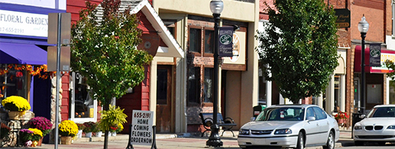
Cities and towns in the U.S. contain more than 130 million acres of forests. These forests vary extensively in size and locale. An urban forest can describe an urban park such as Central Park in New York City, NY, street trees, nature preserves, extensive gardens, or any trees collectively growing within a suburb, city, or town. Urban forestry is the name given to the care and maintenance of those ecosystem areas that remain after urbanization. Data from the 2010 census indicated more than 80% of Americans live in urban centers with a population increase greater than 12%. The population of Indiana represents only 2.1% of the nation. In the last 8 years, IN has had an influx of 200,000 people which represents a population increase of 3.0%!
Urban forests, which help filter air and water, control storm water runoff, help conserve energy and provide shade and animal habitat must be maintained. As our nation becomes more urbanized, appreciate those urban foresters working to ensure we have save urban forest spaces to enjoy. These precious resources add more than curb appeal and economic value, they improve our quality of life.
What does an urban forester do? Here’s a quick answer:
References:
Purdue Urban Forestry & Arboriculture, Purdue Forestry and Natural Resources
USDA Forest Service Urban Forests, United States Department of Agriculture
US Census Bureau, United States Census Bureau
Interested in Purdue Urban Forestry? Contact:
Lindsey Purcell, Chapter Executive Director
Indiana Arborist Association
Ben McCallister, Urban Forestry Specialist
Forestry and Natural Resources
Resources:
Tree Support Systems, The Education Store, Purdue Extension Resource Center
Corrective Pruning for Deciduous Trees, The Education Store
Tree Installation: Process and Practices, The Education Store
What plants can I landscape with in area that floods with hard rain?, Got Nature? Blog, Purdue University Forestry and Natural Resources Extension
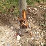
One of the most dangerous pests to trees is a human, especially with equipment. 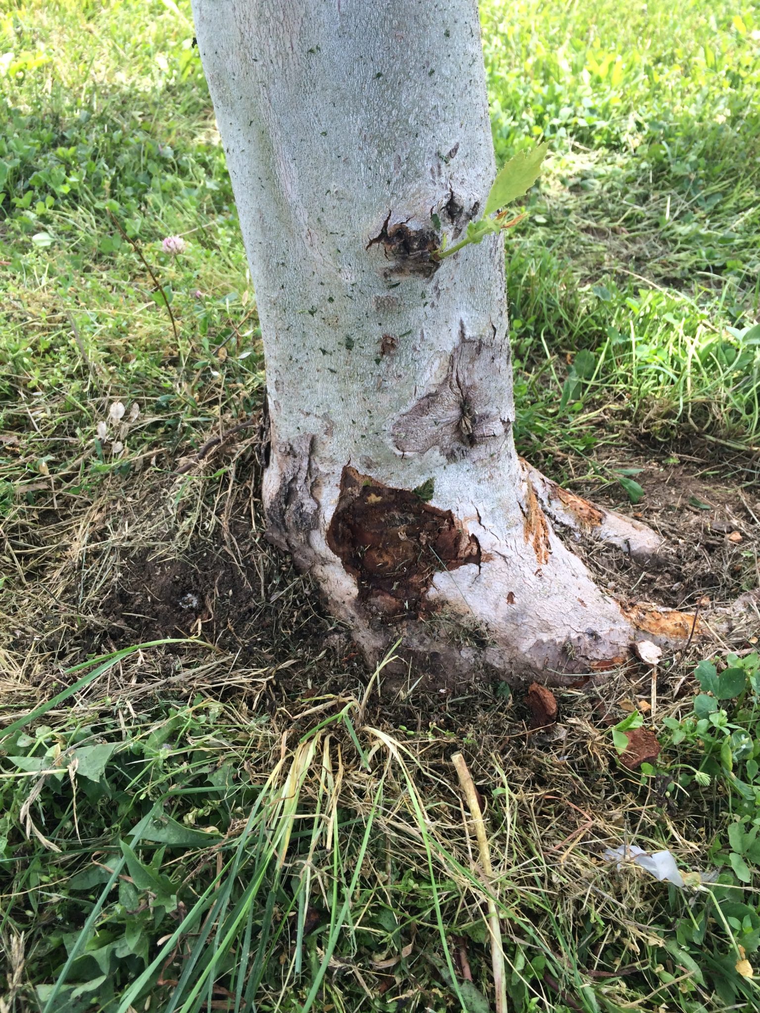 Injuries to trees caused by a lawn mower or weed trimmer can seriously threaten a tree’s health.
Additionally, damage to the bark layer of trees causes a long-term liability by creating a wound which leads to a defect, becoming an unsafe tree.
The site of injury is usually the root flare area, where the tree meets the turf and gets in the path of the mower or trimmer. The bark on a tree acts to protect a very important transport system called the cambium layer.
This is where specialized tubes are located which move nutrients and water between the roots and the leaves. Bark layers can vary in thickness on different tree species. It can be more than an inch in thickness or less than 1/16 of an inch on young, smooth-barked trees such as maples and birch trees. This isn’t much protection against string trimmers and mowing equipment, especially the young trees.
Any type of damage or removal of the bark and the transport system can result in long-term damage. Damage, which extends completely around the base of the tree called girdling, will result in ultimate death in a short time.
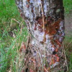
Tree wounds are serious when it comes to tree health. The wounded area is an opportunity for other insects and diseases to enter the tree that causes further damage. Trees can be completely killed from an attack following injuries. Fungi becomes active on the wound surface, causing structural defects from the decay. This weakens the tree or it eventually dies, creating a risk tree to people around it.
Newly planted, young trees need all the help we can provide to become established in the landscape and these trees are often the most commonly and seriously affected by maintenance equipment. However, injury can be avoided easily and at very low cost with these suggestions.
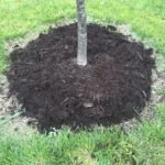 The removal of turf or prevention of grass and weeds from growing at the base of the tree are low-tech solutions to eliminate a serious problem. Spraying herbicides to eliminate vegetation around the base of the tree can decrease mowing maintenance costs. Be sure to use care when applying herbicides around trees.
- A 2-3” layer of mulch on the root zone of the tree provides an attractive and healthy environment for the tree to grow. Additionally, it provides a visual cue to keep equipment away from the tree.
- Also, trunk guards and similar devices can add an additional measure of protection for the tree. Using white, expanding tree guards can help improve the trees ability to withstand equipment contact, but also help to reduce winter injury.

Trees are a major asset to your property and important to our environment. Protect our trees and preserve these valuable assets by staying away from tree trunks with any mowing or weed trimming equipment. The damage lasts and it cannot be repaired and often results in losing your tree.
Purdue University Landscape Report Article
Resources
Corrective Pruning for Deciduous Trees, The Education Store – Purdue Extension resource center
What plants can I landscape with in areas that floods with hard rain?, Purdue Got Nature? Blog
Tree support systems, The Education Store
Tree Installation: Process and Practices, The Education Store
Lindsey Purcell, Urban Forest Specialist
Forestry and Natural Resources
The eastern hellbender is an endangered salamander found in the Blue River in southern Indiana. It requires cool, clean rivers and streams with high water quality in order to thrive. Water quality in the Blue River is affected by many factors. One relatively unknown contributor to poor water quality is pollution entering sinkholes. Many landowners have sinkholes on their properties and treat them like outdoor waste sites without knowing that these sinkholes have a direct link to our water supplies. In this video, Purdue biologists interview a local cave expert and a local conservationist about how sinkholes are connected to our rivers, streams, and water supplies and how we can help protect them.
Resources:
Improving Water Quality by Protecting Sinkholes on Your Property, The Education Store, Purdue Extension’s resource center
A Landowner’s Guide to Sustainable Forestry: Part 5: Forests and Water, The Education Store
Improving Water Quality Around Your Farm, The Education Store, YouTube
Animal Agriculture’s Effect on Water Quality: Pastures and Feedlots, The Education Store
Improving Water Quality At Your Livestock Operation, The Education Store, YouTube
Nick Burgmeier, Research Biologist & Extension Wildlife Specialist
Purdue Department of Forestry and Natural Resources
Dr. Rod Williams, Professor of Wildlife Science
Purdue Department of Forestry and Natural Resources
The Department of Forestry and Natural Resources’ extension team have received four Purdue Extension Issue-Based Action Team (IBAT) awards out of seven. These new initiatives have been chosen from 30 submitted proposals. In an ever-changing world, Purdue Extension is launching big ideas to identify and address priority issues to enhance quality of life as well as the efficiency and/or effectiveness of organizations through research-based education.
Congratulations to the following FNR teams that are moving the world forward:
ENHANCING THE VALUE OF PUBLIC SPACES: HEALTH, WELLNESS, AND DESIGNING THE BUILT ENVIRONMENT
Project Overview: Expand upon the existing Enhancing the Value of Public Spaces program to include a health component — building community capacities for accessible means for physical activity. $50,000.
Team: Michael Wilcox, Assistant Program Leader for Community Development Extension, Purdue Center for Reginal Development; and Kara Salazar, Sustainable Communities Extension Specialist, Department of Forestry & Natural Resources; Donna Vandergraff, Extension Specialist, Nutrition Science; Lisa Graves, Assistant Program Leader and Extension Specialist, Nutrition Science; Melissa Maulding, Director, Nutrition Education Programs; and Steve Yoder, Extension Educator, Agriculture and Natural Resources (ANR), Tippecanoe County.
MARKET BASKET 360
Program Overview: A wealth of resources on a website, educational workshop agendas, certification programs, uniform materials for cooking demonstrations, and more for Farmers’ Market Masters, producers, and consumers. Market Basket 360 centralizes, streamlines, and enhances existing farmers’ market resources available through Purdue Extension, Indiana State Department of Health, the USDA Agricultural Marketing Service, and other industry organizations.
Team: James Wolff, Extension Educator, Agriculture and Natural Resources (ANR), Allen County; Julie Gray, Central District Director, ANR; Morgan Roddy, Extension Educator/Health & Human Sciences (HHS), ANR, Henry County; Curt Campbell, Extension Educator, ANR, Wabash County; Jodee Ellett, Local Foods Coordinator, Purdue Extension; Vickie Hadley, HHS Extension Educator/CED, ANR, Allen County; Nancy Manuel, HHS Extension Educator, ANR, Adams County; Gail Peitzmeier, HHS Extension Educator, Crawford County; Tim Vining, Development Educator, ANR; Teresa Witkoske, HHS Extension Educator/CED, Wabash County; Kwamena Quagrainie, Aquaculture Marketing Director and Associate Professor, Department of Forestry & Natural Resources and Agriculture Economics; Bob Rode, Aquaculture Research Lab Manager and Extension Specialist, Department of Forestry and Natural Resources.
NATURAL RESOURCES LEADERSHIP PROGRAM
Program Overview: Expanding Extension’s capacity to develop and deliver statewide natural resource programs and enhance decision-making for implementation at the community level. $30,000.
Team: Kara Salazar, Assistant Program Leader for Community Development and Sustainable Communities Extension Specialist, Department of Forestry and Natural Resources/Illinois-Indiana Sea Grant; Angie Tilton, Extension Educator, Agriculture and Natural Resources (ANR), Hendricks County Team; Lenny Farlee, Sustaining Hardwood Extension Specialist, Department of Forestry and Natural Resources; Liz Jackson, Hardwood Tree Improvement and Regeneration Center (HTIRC), Engagement Specialist and Executive Director of the Indiana Forestry and Woodland Owners Association and the Walnut Council; Steve Yoder, Regional Extension Educator, Community Development
THE NATURE OF HEALTH
Project Overview: A multifaceted approach to engaging families in nature-learning opportunities that will utilize emerging research to connect Health and Human Sciences and Agriculture and Natural Resources using curriculum developed by Rod Williams titled “The Nature of Teaching.” $20,000.
Team: Rod Williams, Professor of Wildlife Science, Department of Forestry & Natural Resources; Angie Frost, Extension Specialist-Healthy Living, College of Agriculture; Stephanie Woodcox, Extension Specialist-Health & Wellness, College of Health and Human Sciences; Deb Arseneau, Extension Educator, Agriculture Natural Resources (ANR), Newton County; Jay Christiansen, Extension Educator, ANR, Vigo County; Jan Dougan, Extension Educator, ANR, Dubois County; Molly Hoag, Extension Educator, ANR, Wells County; Molly Hunt, Extension Educator, ANR, Delaware County; Gracie Marlatt, Extension Educator, ANR, Rush County; Kelsie Muller, Extension Educator, ANR, Benton County; Lindsey Pedigo, Extension Educator, ANR, Howard County; Katie Zuber, Extension Educator, ANR, Lawrence County.
View the College of Agriculture Strategic Plan and the Purdue Extension Annual Report for more information on Purdue Extension.
For extension resources on Forestry and Natural Resources view Purdue Extension-FNR website.
Diana Evans, Extension and Web Communications Specialist
Purdue University Department of Forestry and Natural Resources
 A Purdue Extension program that helps Indiana communities improve public spaces such as parks and town centers is surveying West Lafayette residents to get input on the city parks and recreation department’s next five-year master plan.
Specialists and educators in Extension’s Enhancing the Value of Public Spaces program are administering the survey and collecting and analyzing the feedback. The objective is to create a five-year plan for improving facilities, services and programs.
Citizens can access the survey online. Those who do not have access to a computer but would like to participate can receive a copy of the survey at the Morton Community Center, the Riverside Skating Center, the Lilly Nature Center and the West Lafayette Parks & Recreation Service Center on Kalberer Road. Deadline to complete the survey is March 15.
“The Enhancing program is strongly rooted in the community development principles of good practice,” said Kara Salazar, sustainable communities Extension specialist. “As such, we concentrate on participation, inclusion, capacity building and balancing action planning with long-term sustainability.”
To read more, check out Purdue Agriculture News‘ full article titled “Purdue Extension program’s objective: enhance public spaces.” Further questions about the survey can be directed to Kara Salazar at 765.496.1070 or salazark@purdue.edu.
Resources:
Purdue Extension program’s objective: enhance public spaces – Purdue Agriculture News
Enhancing the Value of Public Places Home Page – Purdue Extension
Enhancing the Value of Public Places Action Plan – The Education Store, Purdue Extension Resource Center
Kara Salazar, Sustainable Communities Extension Specialist
Purdue University Department of Forestry and Natural Resources
Recent Posts
- Succession Planning Resource: Secure your Future
Posted: December 2, 2025 in Community Development, Land Use, Woodlands - Kara Salazar and Team Win National Runner-up for Innovation & Creativity Award
Posted: September 29, 2025 in Community Development, Land Use, Natural Resource Planning - Hardwood Tree Improvement Regeneration Center (HTIRC) Shares Fall Newsletter, Research and Outreach
Posted: December 13, 2024 in Forestry, Land Use, Natural Resource Planning, Woodlands - Purdue Extension’s Showcase, Impacting Indiana
Posted: November 8, 2024 in Community Development, Forestry, Forests and Street Trees, Gardening, Land Use, Natural Resource Planning, Timber Marketing, Urban Forestry, Wildlife, Wood Products/Manufacturing, Woodlands - American Citizen Planner – Indiana Program Celebrating 4 Years of Impact
Posted: October 16, 2024 in Community Development, Land Use - Publication – Quality of Place and Community Development
Posted: July 18, 2024 in Community Development, Land Use, Publication, Urban Forestry - Publication – Introduction to White-tailed Deer Impacts on Indiana Woodlands
Posted: April 28, 2024 in Forestry, Land Use, Plants, Publication, Wildlife, Woodlands - Publication – Understanding White-tailed Deer and Their Impact on Indiana Woodlands
Posted: in Forestry, Land Use, Plants, Publication, Wildlife, Woodlands - Publication – Monitoring White-tailed Deer and Their Impact on Indiana Woodlands
Posted: in Forestry, Land Use, Plants, Publication, Wildlife, Woodlands - Publication – Managing White-tailed Deer Impacts on Indiana Woodlands
Posted: in Forestry, Land Use, Plants, Publication, Wildlife, Woodlands
Archives
Categories
- Alert
- Aquaculture/Fish
- Aquatic/Aquaculture Resources
- Ask the Expert
- Christmas Trees
- Community Development
- Disease
- Drought
- Forestry
- Forests and Street Trees
- Gardening
- Got Nature for Kids
- Great Lakes
- How To
- Invasive Animal Species
- Invasive Insects
- Invasive Plant Species
- Land Use
- Natural Resource Planning
- Nature of Teaching
- Plants
- Podcasts
- Ponds
- Publication
- Safety
- Spiders
- Timber Marketing
- Uncategorized
- Urban Forestry
- Webinar
- Wildlife
- Wood Products/Manufacturing
- Woodland Management Moment
- Woodlands