 Purdue University - Extension - Forestry and Natural Resources
Got Nature? Blog
ArcGIS.com
Unmanned Aerial Systems and Burn Management Strategies
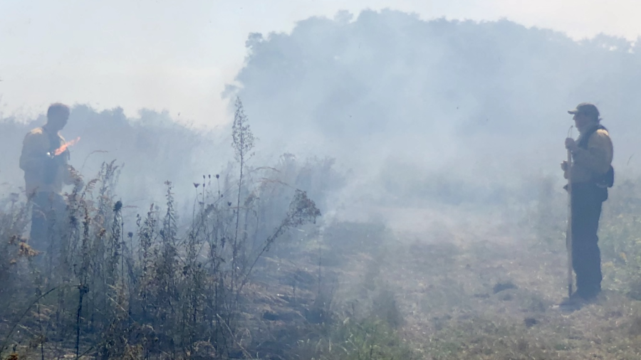
On September 19, 2019 a controlled burn was conducted on the Doak grassland and forest property, owned and managed by the Department of Forestry and Natural Resources at Purdue University. Burn events such as this one present a unique opportunity to demonstrate how UAS can be utilized as an effective tool to both monitor the burn events in real time, but also to effectively gather data before and after the burn to map and better manage vegetation. This collection of maps, videos, and images provide a narrative on how UAS can be used as an effective tool in controlled burn management practices. Beyond controlled burns, the story should demonstrate how UAS can be used to better monitor and inventory other disturbance events, whether they are planned or unexpected.
A Collaborative Effort
The data collected for this event represents a collaborative effort between multiple colleges at Purdue University and private industry. Employees with Purdue Forestry and Natural Resources (College of Agriculture) performed and managed the burn while data collection for the pre and post-burn mapping was conducted by student researchers and pilots from the Purdue School of Aviation and Transportation Technology (SATT; Polytechnic Institute). Peter Menet and Chris Johnson from MenetAero provided aerial monitoring support throughout the controlled burn. A total of three different aircraft were used during this event. The SATT student pilots deployed a C-Astral Bramor PPX equipped with a MicaSense Altum 6 band multispectral sensor at 121 meters before and after the event for mapping purposes. MenetAero deployed a C-Astral C4Eye to monitor the burn in real time using EO/Thermal IR video with real time geographic coordinates at 121 meters while SATT students monitored the burn with a DJI M600 equipped with a Zenmuse XT2 sensor at lower altitudes.
Monitoring the Burn:
The nimble nature of UAS makes them ideally suited to deploy rapidly, and into tight situations otherwise too dangerous for ground crews and manned aircraft. Add to this the aerial perspective offered by UAS via real-time video feed, and you have the perfect platform to assist in hazard events such as fire. The real-time video feed allows the UAS pilot and crew to communicate with ground-based fire crews, providing information on potential hazards and overall fire behavior patterns. For this aerial perspective to be effective, however, the video needs to have geospatial context so what the UAS operator is seeing is effectively communicated to ground-based fire crews. Full-Motion-Video, or video that has metadata with geospatial coordinate information, is a game changer in this regard. The video below shows how software such as Remote Geosystems Line Vision Ultimate can place video in a geospatial context. The video below is being played after the flight, but Pete Menet from MenetAero had the video live streaming to his Ground Station during the flight and was able to effectively serve as an ‘eye in the sky’ to provide real time information to ground based crews. This was all done in a controlled burn, but this same technology and method is used by MenetAero during Wild Fire Events where MenetAero provides UAS services as a contractor with the U.S. Department of Interior. Peter Menet and the MenetAero crew were kind enough to donate their services and time to the controlled burn event this day as part of a collaborative research effort between industry and Purdue.
A Before and After Comparison
Prior to recent advances in UAS technology, gathering imagery at sub-centimeter accuracy and resolution immediately before and after a planned burn event would prove difficult at best. The PPK technology on the C-Astral PPX allowed us to conduct the flights without the need to layout and survey ground control markers, but still achieve centimeter level accuracy by post-processing our data with a Continuously Operating Reference Stations in close proximity. Without UAS, getting satellite data within this time frame would have been pretty much impossible, and getting a manned aircraft to do this prohibitively expensive.
Making Sense of it all through Classification Analysis
Pre-Burn Land Cover Classification
When we think of disturbance events, we often think of the unplanned ones – fire, ice storms, wind storms, floods, etc. But what about planed disturbances such as a controlled burn, or a timber harvest operation? In the case of a planned disturbance, we have the ability to inventory land cover immediately before an event, and then with classification methods, quantify that land cover. Land Use/Cover classification methods are nothing new, and go back to the very beginnings of GIS/Remote Sensing, but new here is the ability to deploy a UAS to get this data in a way that is accurate and precise enough to classify down to resolutions of several square centimeters. Add to that the imagery was gathered less than an hour before the burn and you have some amazing potential for forestland management.
*Thank you to ArcGIS.com for sharing the great work of our FNR specialists as they continue to “strengthen lives and livelihoods” here in Indiana and around the world.
Resources
Unmanned Aerial Systems and Burn Management Strategies, Unmanned Aerial Systems and Burn Management Strategies webpage
Effective Firebreaks for Safe Use of Prescribed Fire, Got Nature? Blog, Purdue University Forestry and Natural Resources Extension
Prescribed fire: 6 things to consider before you ignite, Got Nature? Blog
Renovating native warm-season grass stands for wildlife: A Land Manager’s Guide, The Education Store, Purdue Extension resource center
Calibrating a No-Till Drill for Conservation Plantings and Wildlife Food Plots, The Education Store
Jarred Brooke, Extension Wildlife Specialist
Purdue Department of Forestry and Natural Resources

Recent Posts
- Jarred Brooke Receives Early Career Award for Prescribed Fire Work
Posted: July 20, 2026 in Forestry, Forests and Street Trees, Natural Resource Planning, Safety - Bovine Tuberculosis in Wild White-tailed Deer: Background and Frequently Asked Questions
Posted: in Disease, Natural Resource Planning, Wildlife - ID That Tree: Carolina Buckthorn
Posted: July 15, 2026 in Forestry, Wildlife, Woodlands - Bat Roost Reporting Tool
Posted: July 8, 2026 in Alert, Community Development, Invasive Animal Species, Wildlife - Pruning Highlight; Espalier Pruning: Training Trees into Living Patterns
Posted: in Forestry, Forests and Street Trees, Gardening - Thank You, Turkey Trackers! Your Brood Counts Make a Difference – MyDNR
Posted: in Alert, Community Development, Wildlife - Identifying Evergreens
Posted: June 24, 2026 in Forestry, Wildlife, Woodlands - Celebrate Pollinator Week With Flowers of June Tour
Posted: June 15, 2026 in Forestry, Gardening, How To, Wildlife - Pruning Highlight-Pollarding Trees: A Traditional Pruning Practice with Modern Uses
Posted: June 11, 2026 in Forestry, Forests and Street Trees, Urban Forestry, Wildlife, Woodlands - Danielle Howard Hired as FNR Extension Prescribed Fire Specialist
Posted: June 10, 2026 in Forestry, Wildlife, Woodlands
Archives
Categories
- Alert
- Aquaculture/Fish
- Aquatic/Aquaculture Resources
- Ask the Expert
- Christmas Trees
- Community Development
- Disease
- Drought
- Forestry
- Forests and Street Trees
- Gardening
- Got Nature for Kids
- Great Lakes
- How To
- Invasive Animal Species
- Invasive Insects
- Invasive Plant Species
- Land Use
- Natural Resource Planning
- Nature of Teaching
- Plants
- Podcasts
- Ponds
- Publication
- Safety
- Spiders
- Timber Marketing
- Urban Forestry
- Webinar
- Wildlife
- Wood Products/Manufacturing
- Woodland Management Moment
- Woodlands