
January 23, 2017
Exhibition features the history, art and science of maps
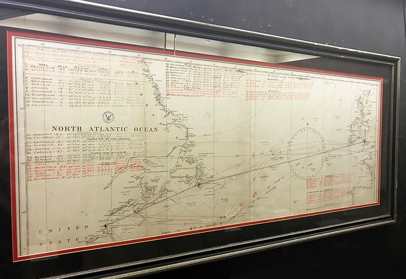 Transatlantic Flight Plan, 1928. Notated map by Wilmer Stultz in preparation of his 1928 transatlantic flight on which Amelia Earhart became the first woman to fly across the Atlantic. Stultz charted multiple possible courses for both directions of the flight. (Photo provided by Purdue Libraries)
Download image
Transatlantic Flight Plan, 1928. Notated map by Wilmer Stultz in preparation of his 1928 transatlantic flight on which Amelia Earhart became the first woman to fly across the Atlantic. Stultz charted multiple possible courses for both directions of the flight. (Photo provided by Purdue Libraries)
Download image
The Purdue Libraries Archives and Special Collections is hosting a new exhibition featuring the history, art and science of maps and the people who created them. The exhibition runs through June 23 in the Virginia Kelly Karnes Archives and Special Collections Research Center.
The exhibition is free and open to the public from 10 a.m. to 4:30 p.m. Monday through Friday.
"Looking Down, Looking Out and Looking Up: Maps and the Human Experience" features maps, books, documents and artifacts spanning from the days of traditional aerial maps, to the expansion of exploration and technology and to the use of star charts, flight plans and lunar maps.
There also are surveying tools, cloth maps used by a World War II pilot and map pins used by Lillian Gilbreth, the first female engineering professor at Purdue.
For more information, contact Adriana Harmeyer at 765-494-2263.
