Limiting space junk’s threat by predicting its mess in the Earth-moon neighborhood
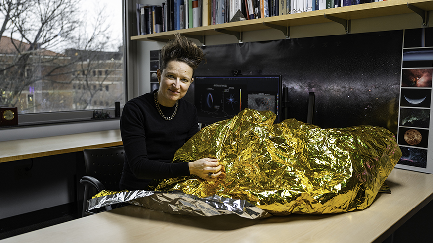
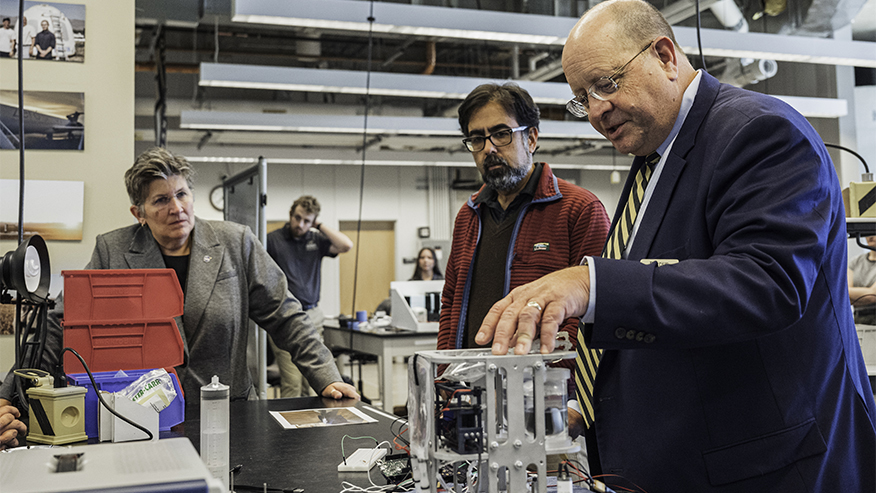
An increase in lunar missions is likely to leave behind more debris on and around the moon. Purdue University engineer Carolin Frueh studies how pieces of spacecraft, such as the shimmering multilayer insulation material in this photo, tend to come off and become space debris. (Purdue University photo/Kelsey Lefever)
WEST LAFAYETTE, Ind. — Debris from moonbound spacecraft has left craters on the lunar surface since the U.S. Apollo missions. But the moon is not used to being surrounded by debris.
With an expected resurgence in lunar missions in the coming years, such as the U.S. Artemis II test flight, Purdue University engineer Carolin Frueh is researching how to track the likely increase in spacecraft debris and minimize its impact in the area between the moon and Earth, called the cislunar region.
In the next decade, at least 30 missions could be launching to the cislunar region.
“Everywhere humans have gone in space, we have left behind space debris. The fewer debris pieces we are creating, the better the problem in the end,” said Frueh, Purdue’s Harold DeGroff Associate Professor of Aeronautics and Astronautics.
Preparing for how new technology — and space itself — could change debris
Frueh’s research considers how the latest spacecraft technology could affect the formation of space debris. Unlike other spacecraft the moon has seen before, for example, rockets for upcoming lunar missions could have nuclear thermal propulsion systems to be more fuel-efficient. But if rockets with these systems collided or exploded, their radioactive contents could disperse and become debris.
Frueh and her students have modeled the consequences of radioactive debris in the cislunar region, finding that nuclear-contaminated fragments from a nuclear thermal propulsion system could emit radiation up to a half-mile away from an impact site on the moon. Their models also indicate that these radiation levels could stay elevated for at least a year, threatening a lunar base if built nearby.
On the other hand, radioactive debris could float in other directions around the moon and have less impact.
“There are better and worse locations for fragmentation. The pieces could hit a moon colony — or not. But we still need to be careful because it’s not obvious where fragments will congregate,” Frueh said.
A “better” mess is still problematic because space doesn’t stay the same, and telescopes on Earth currently aren’t able to view the whole cislunar region to track where fragments and spacecraft go. Frueh and her students are working to remove these blind spots by creating comprehensive “visibility maps” that indicate where telescopes on satellites should be placed in cislunar space to observe as much of the region as possible.
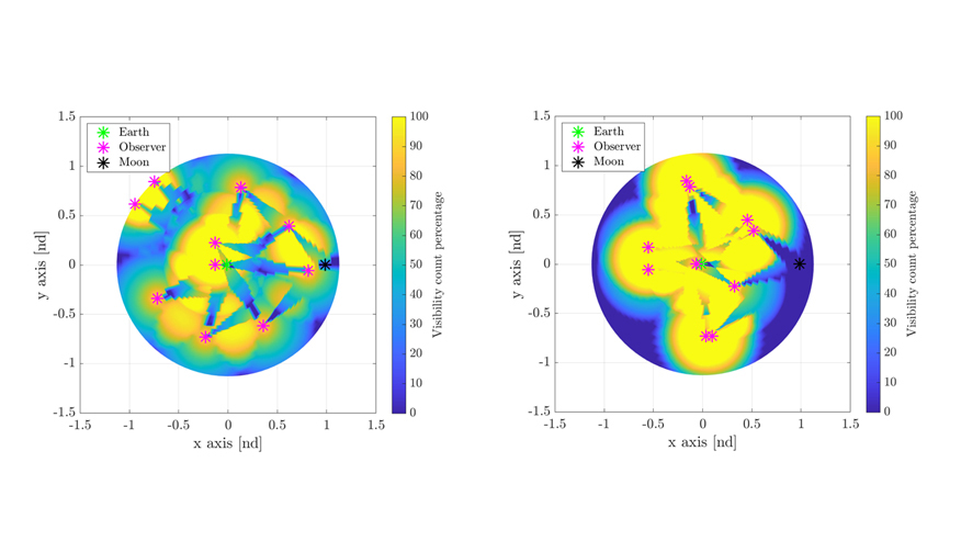
To consider the always-changing nature of space, Frueh’s lab generates these maps using models that average out the orbits a telescope might use over a 30-day period and incorporate the constant movement of the Earth, moon and sun. The approach is more efficient than other mapping methods, which must rerun a model for each condition that would affect a telescope’s orbit and overall viewing geometry at each instance in time.
In a paper published in The Journal of the Astronautical Sciences, Frueh’s research group used their maps to show possible ways to increase visibility rate success from 10% to 90% for a constellation of up to 10 telescopes in cislunar space. She and her students also demonstrated that a method they developed could help test and improve trajectories a telescope may use to travel between regions of optimal visibility.
Using AI to evaluate if space objects might hit each other
While working on solutions for the cislunar region, Frueh’s research also extends to low Earth orbit, the messiest region in space.
Most organizations have satellite operators available 24 hours a day year-round to monitor satellites and prevent collisions between them. But as the number of satellites in space increases, it will get much harder to watch them all. Each satellite operator also evaluates collision risk differently according to their organization’s policies, even when given the same data, Frueh’s lab observed in a study.
Frueh and PhD student Pavithra Ravi surveyed how satellite operators across five organizations decided whether to relocate satellites at risk of collision for 30 scenarios in low Earth orbit. The researchers then trained a machine learning model on two sets of data. One dataset had more than 300,000 physics-based simulated events closely mimicking reality, and the other set had 8,000 real confirmed collisions and misses in low Earth orbit.
They tested the model on the same 30 scenarios the satellite operators had evaluated. Frueh and her students found that the machine learning model was able to mimic the decision-making of each satellite operator with high reliability, correctly detecting probable collisions most of the time and prioritizing safety in deciding if satellites should change position.
“The idea would be to reduce the workload of analysts looking at all these cases while maintaining a given organization’s priorities. The model could either make decisions about satellite maneuvers completely autonomously or give the analyst some guidance,” Frueh said.
Diagnosing problems with satellites before they create a mess
When a satellite gets stuck in space because it malfunctioned or lost communication with its operator, finding out how the satellite is oriented can help with getting it unstuck before it becomes debris. The orientation could reveal if the satellite is rotating, tumbling or stable, for example.
Frueh is one of the few researchers in the world working to improve a technique that uses sunlight to estimate the orientation of a satellite or its fragments.
Most satellites are constantly illuminated by the sun and can be seen as white dots with a telescope. The technique Frueh uses tracks changes in the brightness of these dots over time, which form “light curves” on a graph.
This method would be less expensive than radar and provides information about a satellite no matter how far away it is from Earth as long as the satellite reflects some light toward the telescope on the ground. Radar, although more detailed, is typically limited to satellites at low altitudes because of energy constraints.
“With light curves, we’re not seeing any detail — just a bright dot. Changes in information about the object’s orientation, shape and reflectivity are all embedded in that dot,” Frueh said.
However, information from that white dot is often ambiguous. Frueh, PhD student Liam Robinson and others in her research group have developed an algorithm that provides all the possible orientations of a satellite given the information available. They have shown with measurement data of real space objects that the algorithm can reliably determine a satellite’s orientation, overcoming a major challenge in making light curves practical for use.
The light curves method could also be useful for actively removing space debris.
“The better we know about the pieces we’re dealing with — what’s the shape, how much rotation they have — the better we can execute missions to remove those pieces,” Frueh said.
Frueh’s work on these studies is primarily supported by the U.S. Air Force Office of Scientific Research and the European Space Agency.
ADDITIONAL INFORMATION
- In-space manufacturing, quantum projects part of all-Boilermaker suborbital spaceflight
- Academic, industry and government partners chart future of physical AI in space at Rice-led event
- New NASA astronaut candidates become Purdue’s 29th and 30th members of Cradle of Astronauts
- Purdue announces launch of Neil Armstrong Space Prize
- Purdue’s enduring legacy in space exploration
About Purdue University
Purdue University is a public research university leading with excellence at scale. Ranked among top 10 public universities in the United States, Purdue discovers, disseminates and deploys knowledge with a quality and at a scale second to none. More than 106,000 students study at Purdue across multiple campuses, locations and modalities, including more than 57,000 at our main campus locations in West Lafayette and Indianapolis. Committed to affordability and accessibility, Purdue’s main campus has frozen tuition 14 years in a row. See how Purdue never stops in the persistent pursuit of the next giant leap — including its integrated, comprehensive Indianapolis urban expansion; the Mitch Daniels School of Business; Purdue Computes; and the One Health initiative — at https://www.purdue.edu/president/strategic-initiatives.
Papers
A comprehensive review on cislunar expansion and space domain awareness
Progress in Aerospace Sciences
DOI: 10.1016/j.paerosci.2024.101019
Characterization of consequences of fragmentation events involving nuclear-powered spacecraft in the cislunar region
9th European Conference on Space Debris
Paper is available on the European Space Agency Conference Proceedings website.
Cislunar key region surveillance optimization
The Journal of the Astronautical Sciences
DOI: 10.1007/s40295-025-00522-6
Comparative analysis of collision avoidance decision-making across organizations
9th European Conference on Space Debris
Paper is available on the European Space Agency Conference Proceedings website.
Global light curve attitude estimation with noisy measurements and inertia uncertainty
The Journal of the Astronautical Sciences
DOI: 10.1007/s40295-025-00557-9
Optimal light curve attitude inversion with measurement noise: Two case studies
9th European Conference on Space Debris
Paper is available on the European Space Agency Conference Proceedings website.
Media contact: Kayla Albert, 765-494-2432, wiles5@purdue.edu
Note to journalists:
A video of Carolin Frueh discussing the lasting impact of space debris, along with high-resolution photos of her research, are available via Google Drive.
Space News

Purdue’s space work is featured at NASA Science Showcase
April 28, 2026
NASA associate administrator visits Purdue, tours research facilities
April 22, 2026

SpaceX team wins Purdue’s first Neil Armstrong Space Prize for its reusable rocket system
April 21, 2026
2 Purdue alumnae complete the crew of the Virgin Galactic all-Boilermaker spaceflight
April 15, 2026