Geospatial data project will let almost anyone put almost anything on map
November 20, 2013
 |
|
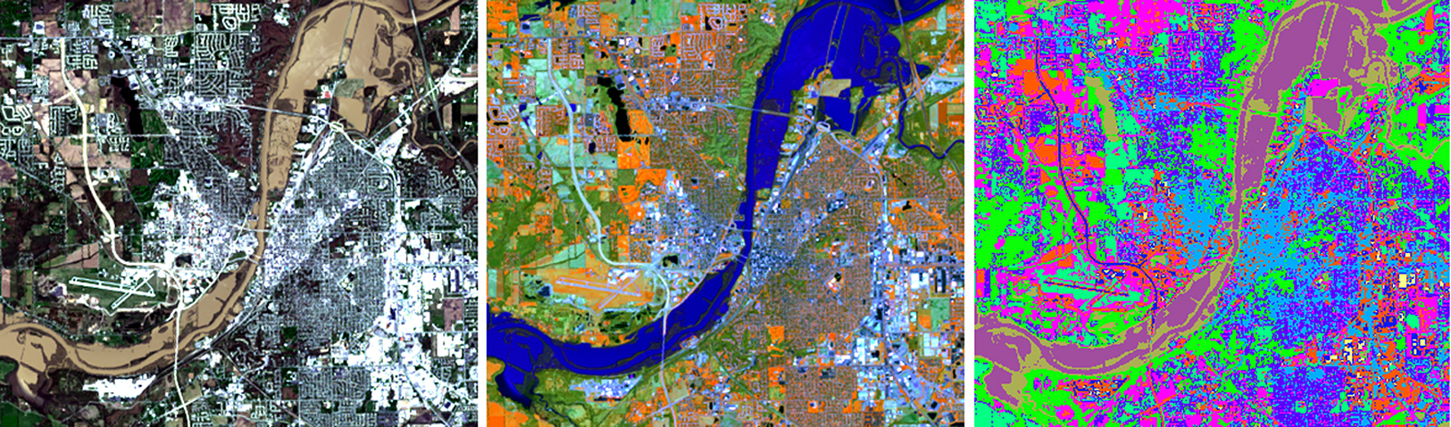
This is a satellite image of flooding on the Wabash River between Lafayette and West Lafayette, Ind., in 2013. Shown are variations in the wavelengths of light reflected from the surface to highlight the extent of water and features such as vegetation and bare ground. The last version represents a grouping of the data into various land cover classes. (Information Technology at Purdue image) Download Photo |
WEST LAFAYETTE, Ind. – A powerful Web-based system enabling people worldwide to better predict such things as damaging floods and potential effects of climate change is the goal of a $4.5 million, four-year project begun by Purdue University researchers.
The project, funded by the National Science Foundation, will add geospatial data hosting, processing and sharing capabilities to Purdue's HUBzero, a platform for building feature-rich websites enabling research and education. This should open the way for easy development of a variety of Web-enabled tools for probing and presenting geospatial data in ways that can help address pressing issues in the United States and around the globe.
Geospatial data can include maps, aerial photos, satellite imagery, sensor output and almost anything able to be "georeferenced," or located on a map, from field-level crop yields and local population densities to regional weather and climatological records and the flow of trade in specific commodities across national borders.
Mapping such data, particularly in layers that integrate information on an array of factors and can show how they may interact, is a powerful way to glean new and improved knowledge from data collections and to explain the results to policymakers and the public.
"We want to have tools where people can integrate multiple data sets in the way they want and extract information based on these multiple data sets," says Venkatesh Merwade, associate professor of civil engineering.
The project should open geospatial data and sophisticated analysis tools - many of them common to a geographic information system (GIS) - to almost anyone, anywhere and allow ready sharing of data and results, as well as collaboration among users, whether on the same campus, across the country, or across the planet.
"I'm here at a first-class university, I have all the software I need and a fast Internet connection to download large amounts of data and I have the expertise to handle that data; if I don't have it, probably down the hall somebody has it," says Nelson Villoria, a research assistant professor at Purdue's Center for Global Trade Analysis. "Not everyone is as fortunate. We're doing something that will lower the barriers to using this sort of information."
The geospatial data project stems from earlier, specialized projects involving HUBzero and focused on causes and effects of droughts, water resources, and agriculture, land use and the environment.
"We have developed many map-driven and sophisticated online tools for modeling and visualization of geospatial data, which typically require significant geographic information system and software expertise," says Carol Song, a Purdue senior research scientist and the principal leader of the project. "In this project, we will be able to share what we have learned, expand on it and make it available to anyone through the HUBzero open source software."
Merwade, Villoria and Purdue research scientist Larry Biehl are co-leaders of the project. Thomas Hertel, Distinguished Professor of Agricultural Economics and executive director of the Center for Global Trade Analysis, is a project adviser.
The project is funded through the NSF's Data Infrastructure Building Blocks program. Several partners, from K-12 educators to large NSF projects, have signed on to test the new geospatial tools as they become available. The Purdue researchers will work with the Geography Educators Network of Indiana (GENI) to provide school students with engaging online activities that improve comprehension of geography, GIS, remote sensing and other geospatially related topics.
Merwade and Villoria also will mount test projects to demonstrate the power of a geospatial-capable hub.
In Merwade's case, that involves building a hydrologic model of the entire Mississippi River Basin incorporating large amounts of data on factors such as weather, land use, topography, soil and more. When done, the tool should allow users to generate stream flow projections and predict when floods may occur anywhere in the Mississippi Basin, which encompasses all or parts of 31 U.S. states and two Canadian provinces between the Rocky and Appalachian mountains.
"We want to tackle substantive policy issues, things that change the way people think and lead to policy actions, or at the very least inform the debate about policy," says Villoria, whose test project will look at climate change impacts on poverty.
The new capabilities will be incorporated in the freely available open source version of HUBzero, making them available to current hub owners or those who want to build a hub.
A major HUBzero feature is its ability to make computational research tools and visualization and analysis of results, easily available through a Web browser. Built-in collaboration features create online communities around a topic. The platform also offers data management and interactive database capabilities and simplified access to supercomputers and cloud computing.
More than 50 hubs based on HUBzero now serve many areas of science, engineering and other fields, from nanotechnology, cancer treatment and advanced manufacturing to earthquake engineering, pharmaceutical and biofuels development, and the bonds between human and companion animals.
Writer: Greg Kline, 765-494-8167, gkline@purdue.edu
Sources: Carol Song, 765-496-7467, carolxsong@purdue.edu
Venkatesh Merwade, 765-494-2176, vmerwade@purdue.edu
Nelson Villoria, 765-494-4303, nvillori@purdue.edu
