
Insect Pest Management
Building on our migration research, we apply isotope geolocation to agricultural and forestry pests, with a strong focus on North American biosecurity. By integrating isotopes with radar monitoring, population genomics, and spatial modeling, we trace the origins, dispersal pathways, and outbreak dynamics of species such as the eastern spruce budworm and other migratory pests. The goal is to establish isotope geolocation as a core tool for pest provenance, invasive-species management, and early-warning systems under climate change — directly relevant to U.S. agriculture and forestry.
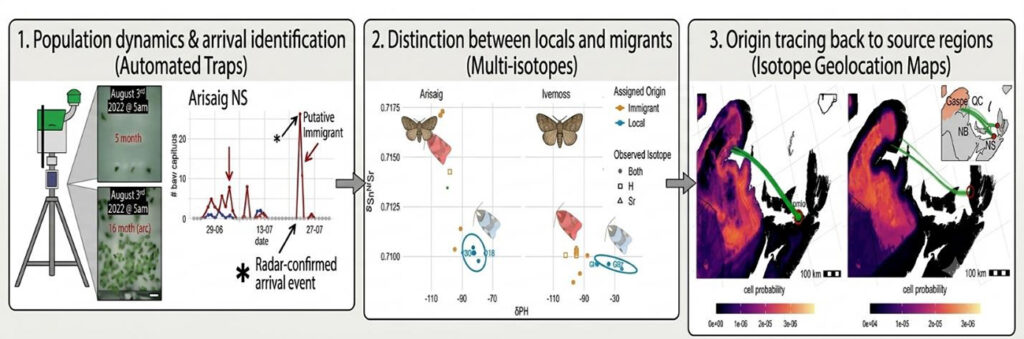
An Integrated, Automated Workflow for Pest Monitoring and Isotope Geolocation.
This multi-stage process demonstrates the pipeline from automated detection to tracing source regions, modified from Dargent et al. 2023 and 2026.
- Population Dynamics and Arrival Identification – Automated Traps: (Panel 1): Demonstration of a tripod-mounted automated pheromone trap (far left) equipped with a camera to monitor moth catch in real-time. The example data from Arisaig, NS (graphs) shows a sudden, late-season spike in adult abundance in late July. Integrated radar data confirms a major atmospheric movement event (asterisk, “Radar-confirmed arrival event”), while the disproportionate spike in adult males compared to local larvae suggests a “Putative Immigrant” event.
- Distinction Between Locals and Migrants – Multi-Isotopes: (Panel 2): Standard bivariate plot showing carbon (δ¹³C) and strontium (⁸⁷Sr/⁸⁶Sr) isotope values for collected adult moths from Arisaig (circles) and Iverness (squares). Reference moth wing icons (Arisaig = left, Iverness = right) visualize typical local phenotypes. By comparing sample isotope values to modeled local isoscape values (not pictured, but derived from water and geological data), collected individuals are assigned a “Local” or “Immigrant” origin, clearly distinguishing two distinct genetic clusters at Arisaig.
- Origin Tracing Back to Source Regions – Isotope Geolocation Maps: (Panel 3): Two examples of geographical assignment for immigrants. The “cell probability” color gradient maps represent the likelihood of origin across the study region. Using multi-isotope assignment, source regions for these individuals are traced back to the Gaspe Peninsula (left map) and specific regions in the defoliated regions of New Brunswick and Nova Scotia (right map and inset). Backward wind trajectory models (green lines) further substantiate these pathways, linking specific weather events to pest movement.
Natural Resource Application
Stable isotope geolocation plays a central role in transforming insect surveillance into actionable intelligence. Because insects incorporate environmental isotope signatures into their tissues during development, isotopic analysis provides a natural and scalable way to infer geographic origin without direct tracking. This is particularly critical for migratory species, where long-distance dispersal and small body size make traditional tracking methods impractical. By linking captured individuals to spatially explicit isotope baselines (isoscapes), this framework enables the reconstruction of movement pathways and source regions across large spatial scales. When coupled with monitoring networks, isotope-derived assignments allow managers to rapidly identify invasion routes, distinguish local emergence from long-distance migration, and prioritize intervention points. Crucially, isotope geolocation integrates seamlessly with other data streams, strengthening confidence in origin assignments and enabling real-time, data-driven management decisions. In this system, isotopes are not just an analytical tool—they are the key mechanism that converts scattered observations into a coherent picture of migratory connectivity, enabling earlier detection, more precise targeting, and more effective control of insect populations.
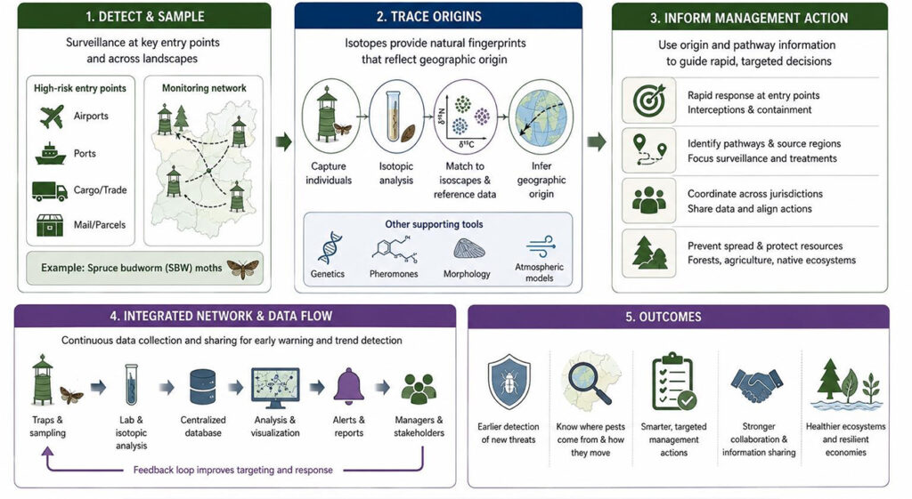
End-to-end framework for detecting, tracing, and managing migratory insect populations using isotope-informed surveillance.
Insects are sampled across entry points and monitoring networks, then analyzed using stable isotopes to infer geographic origins based on environmental fingerprints. These origin assignments, integrated with complementary tools (genetics, morphology, atmospheric models), guide targeted management actions. Continuous data flow and feedback loops support early warning, coordinated responses, and improved outcomes, including reduced spread, targeted interventions, and more resilient ecosystems.