
| RELATED INFO |
| * VORTEX 2 project |
| * VORTEX 2 blog |
| * Purdue Severe Weather Research Group |
| * Purdue Climate Change Research Center |
| * NSF news release |
| * NSF media advisory |
![]()
![]()
May 21, 2009
Purdue swept up in largest tornado field study in history
WEST LAFAYETTE, Ind. -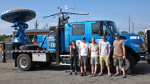 |
A project led by Jeff Trapp, an associate professor of earth and atmospheric sciences, is part of the second Verification of the Origins of Rotation in Tornadoes Experiment, or VORTEX 2, field study.
The more than $9 million study, funded by the National Science Foundation and the National Oceanic and Atmospheric Administration, involves scientists from 14 universities and institutions and is sampling supercell thunderstorms and tornadoes that form over the Great Plains of the United States through June 13.
"Through this field study we hope to discover more about what causes a tornado, why one becomes stronger than another and what characteristics of the tornado cause damage," said Trapp, who also was involved in the first VORTEX study in 1994 and 1995. "This information will help scientists issue more timely warnings, predict the potential strength of a pending tornado and provide insight into the wind variations over time and space that, in addition to wind speed, lead to the most damage."
Trapp is one of the principal investigators of the Doppler on Wheels, or DOW, branch of the VORTEX 2 field project. The Doppler on Wheels are mobile weather radars used to capture data underneath and within supercell thunderstorms and tornadoes. Two of Trapp's students and three student volunteers from Purdue also are participating in the study.
The DOW team plans to use the data to improve the accuracy of the tornado record and to develop methods to better use available weather data to predict a tornado.
"Ultimately we hope to improve estimates of tornado occurrence and strength," Trapp said. "The current system relies on eyewitness reports and damage left behind in the evaluation of tornadoes."
The current evaluation of tornado strength is the Enhanced Fujita scale, which uses assessed damage to estimate the wind speeds of a tornado. The scale is limited because there have not been direct measurements taken to constrain or calibrate it, Trapp said.
"It also brings up the 'If a tree falls in a forest' adage," he said. "For example, a tornado that occurs at night and does not leave much damage in its wake may escape entry into the record at all. Or a very strong tornado that occurs over an open field and causes no damage will go down in the record as a weak tornado."
The accuracy of the tornado record and the map of where tornadoes have occurred are critical to the development of more accurate and earlier tornado warnings, he said.
"The record of tornado occurrence and intensity and the atmospheric factors that surrounded the storm provide the clues scientists use to forecast tornadoes and warn of an imminent danger," Trapp said. "We plan to compare our high-resolution measurements of the storms with Nexrad data. This should allow us to develop a way to better use the existing radar networks to evaluate tornado strength and warn of their development."
Next-Generation Radar, or Nexrad, is the network of Doppler weather radars operated by the National Weather Service. These radars were deployed in 1988 to detect precipitation and wind movement and are used by meteorologists to forecast the weather.
Trapp's team will measure information such as wind speeds, atmospheric pressure and temperature within a mile of the tornado using the DOWs and also tornado pods. The team will then combine this information with Nexrad data through a computer model.
The tornado pods are more rugged than the DOWs and are used to measure wind, pressure and temperature close to the ground below a storm or tornado. These instruments supplement the DOW radar data, which remotely sense winds from approximately 100 feet above the ground to thousands of feet above through the depth of the atmosphere, Trapp said.
The data from the computer model also could be used to retroactively improve the tornado record and unveil trends in their occurrence and strength, he said.
"There is a looming question of the possible role of climate change in tornado frequency," Trapp said. "We don't know what the true trend of tornadoes has been over the last 20 to 50 years. With this technique we could go back in time over the period we've had Nexrad data and figure out an improved estimate of what the frequency has been and identify any trends."
VORTEX 2 involves more than 50 scientists and 40 research vehicles, including 10 mobile radars.
Areas of focus include southern South Dakota, western Iowa, eastern Colorado, Nebraska, Kansas, the Texas panhandle and western Oklahoma.
Writer: Elizabeth Gardner, (765) 494-2081, ekgardner@purdue.edu
Source: R. Jeff Trapp, (765) 496-6661, jtrapp@purdue.edu
Purdue News Service: (765) 494-2096; purduenews@purdue.edu
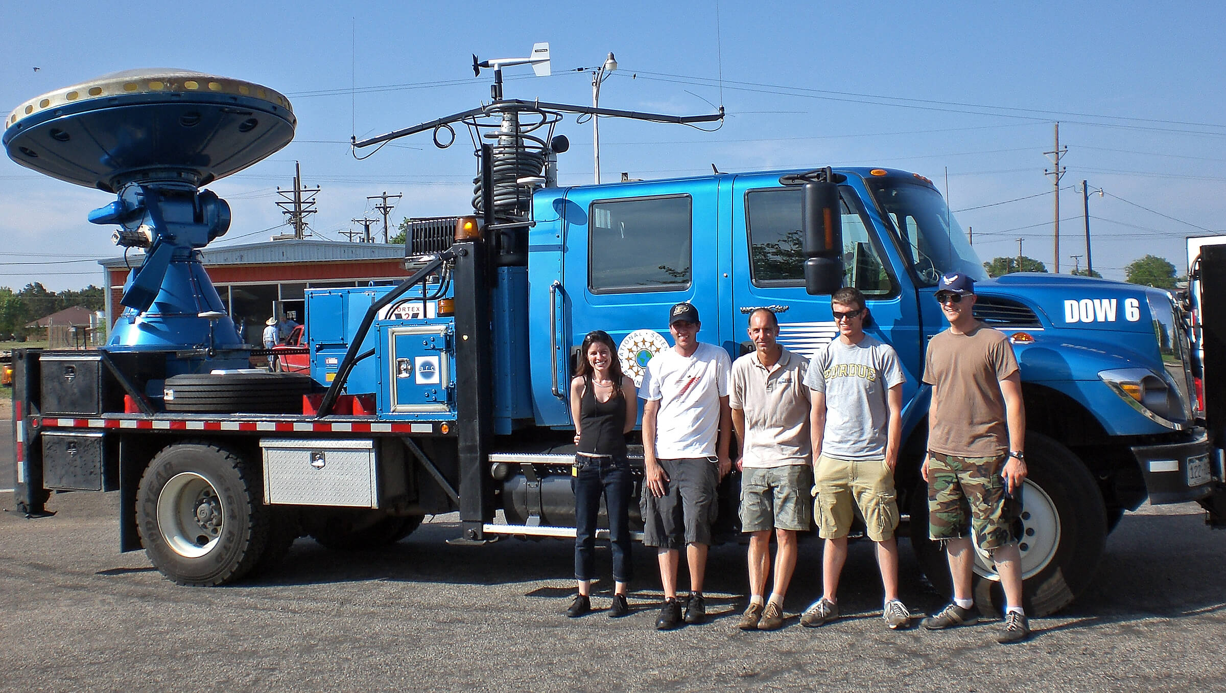
PHOTO CAPTION:
Members of the Doppler on Wheels team stand in front of its research vehicle. From left are postdoctoral researcher Karen Kosiba; student Andrew Arnold; Jeff Trapp, associate professor of earth and atmospheric sciences; and students Jacob Carley and Kevin Burris. The team is part of the Verification of the Origins of Rotation in Tornadoes Experiment, or VORTEX 2, field study. (Purdue University photo courtesy of Jeff Trapp)
A publication-quality image is available at https://www.purdue.edu/uns/images/+2009/weather-research.jpg
To the News Service home page
![]()