
December 15, 2005
Ancient glaciers still affect the shape of North America, say scientists
WEST LAFAYETTE, Ind. – Long after the disappearance of the glaciers that once covered much of North America, the land they rested upon is still recovering from their weight – and the slow movement of this recovery includes horizontal motion never seen before, say Purdue scientists.

|
The research team, led by Eric A. Calais, has found that a large swath of territory in the Northeast is slowly moving southward in relation to the rest of the continent. This region, once covered with massive ice sheets heavy enough to deform the very stone they rested upon, has long been known to be rising slowly in response to the glaciers' retreat, but this response has now been observed to have a horizontal component as well. The southward movement does not appear to be dramatic – in most places it is on the order of a millimeter per year or less – but it calls into question a view that earth scientists have held about crustal plates for three decades, namely that these large, rocky chunks of the planet's surface are rigid objects.
"Our findings do not disprove this view entirely, but they encourage us to see that deviations to the rule can occur," said Calais, an associate professor of geophysics in Purdue's College of Science. "We are now in a position to measure just how rigid these plates are, and in some areas, such as those still rebounding from the glaciers, we are finding movement we had never seen. This movement contains critical clues regarding the viscosity of the earth's interior, which is impossible to measure directly. The movement may even influence seismic activity in places such as Quebec, which is from plate boundaries but has nonetheless suffered from strong earthquakes."

|
The findings appear in the current issue of the scientific journal, Nature. Members of the team hail from seven different institutions, including the University of Arkansas' G. Mattioli, the University of Wisconsin's C. DeMets, CNRS France's J.-M. Nocquet, Northwestern University's S. Stein, the Georgia Institute of Technology's A. Newman and the University of Memphis' P. Rydelek.
Earthquakes often strike areas near plate boundaries, where large chunks of the earth's outer shell grind against one another and create powerful waves that shatter the nearby surface. The resulting cracks in the land, such as California's San Andreas fault, are well-known earthquake source spots that result from the North American plate's contact with the nearby Pacific plate. But less understood are the powerful, but thankfully rare, earthquakes that strike the interiors of continents. For example, the New Madrid Seismic Zone, which stretches from southeastern Missouri to Memphis, Tenn., lies thousands of miles from plate boundaries but has experienced several large quakes in 1811-12, raising local earthquake insurance premiums in the region to levels comparable to those in San Francisco.
"We were looking for evidence that such areas are still deforming today in hope to better define their seismic potential," Calais said. "Past attempts to settle the argument have turned up conflicting data, but recent improvements in Global Positioning System technology have allowed us to measure the continent's rigidity with greater accuracy. We found that such local deformations are too slow to be picked up by our instruments but serendipitously discovered how the continent deforms at a larger scale."
The Global Positioning System, or GPS, uses 24 satellites to make precision measurements of locations on the Earth's surface. In addition to the familiar application of helping travelers navigate in unfamiliar territory, GPS can measure physical alterations to the territory itself, with an accuracy of about a millimeter per year. Earth scientists have placed hundreds of GPS stations around the continent to assist with studies of how the figure of the planet changes over time. Some of those changes, Calais said, are already well understood – or so the researchers thought.
"We already knew that parts of North America are slowly rising due to an effect we call post-glacial rebound," he said. "The weight of the ice sheets that once covered the region was large enough to deflect the surface beneath it, lowering its elevation. Now that the ice sheets are gone, the land is recovering slowly – so slowly that it is still rising today, 10,000 years later."
What the team's study showed, however, was that the region is not merely rising in elevation, but also expanding outward at a slow but noticeable rate.
"You might imagine trying to flatten out a plastic bowl by pushing it up from the bottom," Calais explained. "As you push up in the middle, it rises, but it also forces the edges outward. That's very likely the sort of effect we're observing because other explanations do not fit the data very well."
Calais cautions, however, that the observed movement is quite small compared to other typical earthquake-generating tectonic activity; land along the San Andreas fault, for example, moves 30 times faster per year or more than the newly measured movement. The scientific significance of the study, he said, lies primarily in the discovery of a new behavior in the Earth's crust.
"We still do not know how this behavior is connected to earthquakes," Calais said. "It is a relatively slow motion, and it's too soon to say whether it affects fault lines far away in Missouri or anywhere else for that matter. But, more interestingly, this behavior is telling us something about the strength of the interior of our planet, a fundamental property we have no way of measuring directly. The stronger it is, the longer it takes for post-glacial effects to dissipate.
"We are starting to decipher a subtle message left at the earth's surface by processes happening thousands of kilometers under our feet. The planet still has lessons to teach us."
This research was funded by the U.S. Geological Survey.
Writer: Chad Boutin, (765) 494-2081, cboutin@purdue.edu
Source: Eric Calais, (765) 496-2915, ecalais@purdue.edu
Purdue News Service: (765) 494-2096; purduenews@purdue.edu
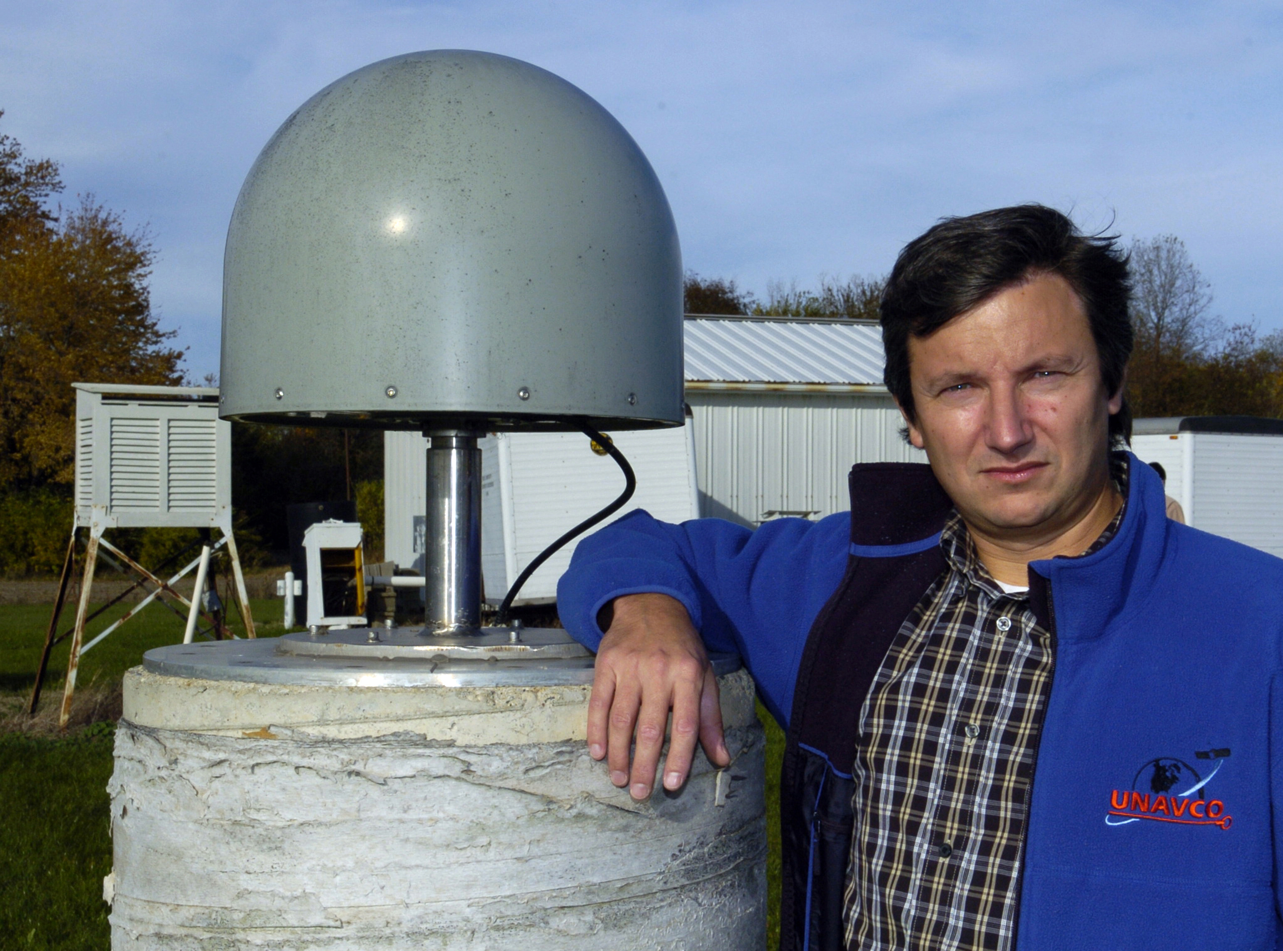
IMAGE CAPTION
Purdue University geophysicist Eric Calais stands next to a Global Positioning System station of the sort his research team used to discover movements never before detected in the Earth's crust. Precise satellite observation of GPS stations across North America revealed that portions of the northeastern section of the continent are moving southward at rates on the order of 1 mm per year. The horizontal motion, which is likely a "rebounding" of the surface in response to the melting of the heavy glaciers that once covered the region, complements the vertical rebounding effect that geophysicists have been aware of for years. Whether this newly discovered motion affects earthquake activity is not yet known. (Purdue University photo/Dave Umberger)
A publication-quality photo is available at https://www.purdue.edu/uns/images/+2005/calais-earthquake.jpg
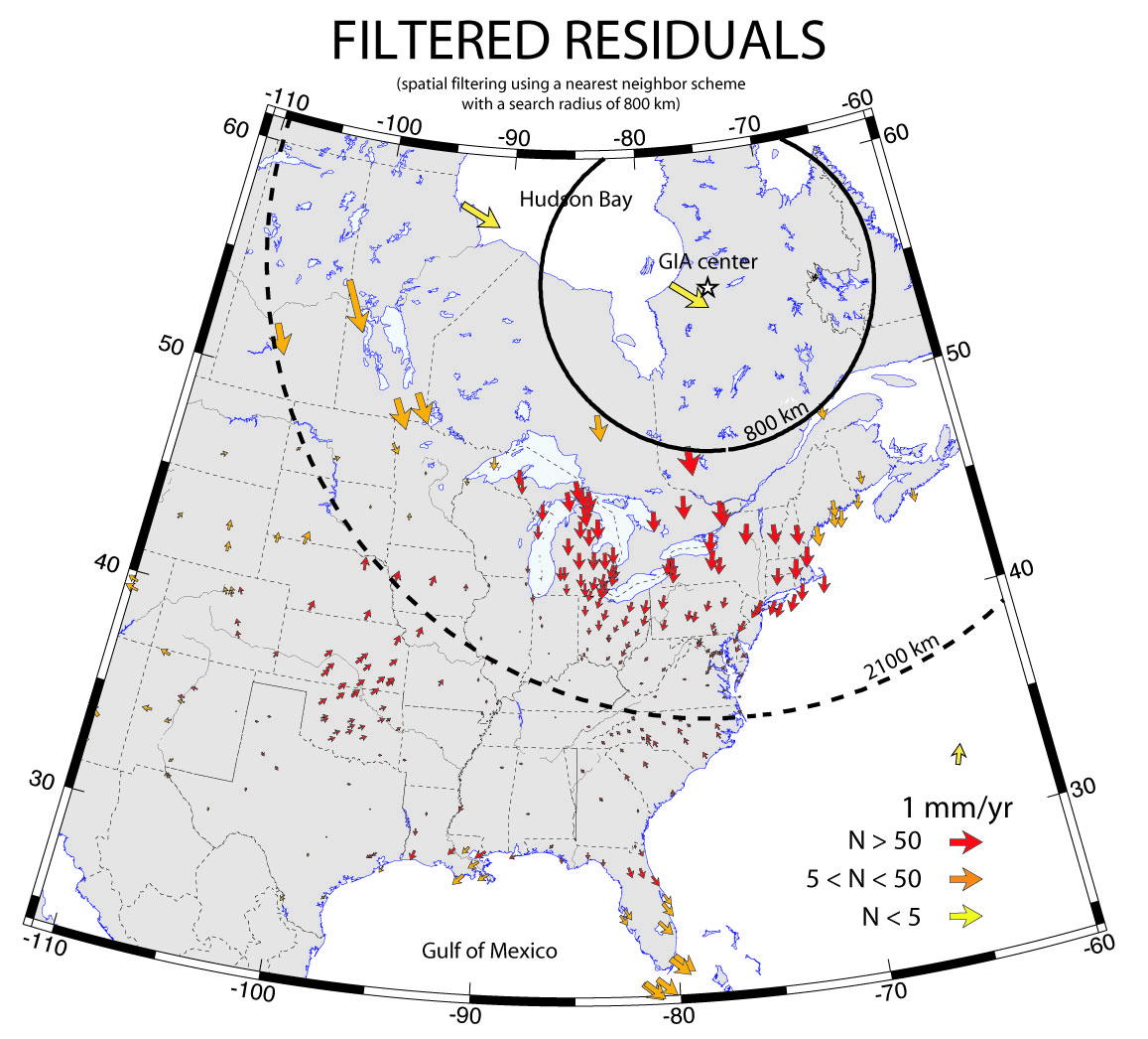
IMAGE CAPTION
Arrows on this map indicate the present-day horizontal movements of the Earth's surface in North America, which a recent Purdue University study has determined is not a completely rigid land mass as scientists had previously thought. Precise Global Positioning System measurements at several hundred sites indicate that the northern part of the continent is moving generally southward at rates up to 1 mm per year. This expansive movement is a response to the lightened load on the Earth's crust as the ice sheet that covered Canada and parts of the United States melted at the end of the last ice age. This new image of how a continent deforms may provide insights into earthquake activity in areas far from tectonic plate boundaries, activity that still remains a mystery to science and will help scientists understand the mechanical properties of the Earth's deep interior. Larger arrows indicate areas experiencing faster movement; red arrows indicate regions with the most GPS measurements, indicating areas with the most robust data. (Purdue University graphic/Calais labs)
A publication-quality photo is available at https://www.purdue.edu/uns/images/+2005/calais-earthquake2.jpg
Tectonic Strain in the Interior
of the North American Plate?
Geologists have long sought to understand how and why the interior of tectonic plates deform, leading to large, although infrequent, earthquakes. A recently published potential breakthrough suggests that surface deformation in the central U.S. accumulates at rates comparable to those across plate boundaries. However, three analyses of the same dataset find no statistically significant deformation. Therefore, only upper bounds on large earthquake magnitude and repeat time can presently be inferred.
To the News Service home page