 Purdue News
Purdue News
|
|
|
October 1999
Future imaging satellites to have everyday applicationsWEST LAFAYETTE, Ind. -- Researchers are creating software that will make satellite imaging systems so user-friendly that they might soon be accessible to everyone from farmers to real estate developers.
"The analogy I use is that you don't need to have detailed knowledge of how an internal combustion engine works to drive a car," says David Landgrebe, a professor in the Purdue University School of Electrical and Computer Engineering. He is developing computer algorithms that perform the rigorous computational work, promising to make highly detailed satellite imaging a practical tool for the everyday world. Such algorithms are increasingly desirable with the continued improvement of imaging satellites, which are providing more data that can be used in applications from agriculture to transportation planning. Satellites are getting better at distinguishing between rooftops, roads, vegetation and other surface characteristics. The new algorithms will make these data more readily available to users who have little technical expertise. "We want to come up with ways that will enable most anybody to do it," Landgrebe says. He discussed progress in the field in a keynote lecture July 27 at the Fourth International Conference on GeoComputation at Mary Washington College in Fredericksburg, Va. Landgrebe, who says the applications are likely to expand within a few years, was a science adviser for an imaging satellite project that is scheduled for a December launch. The Earth Observing satellite, managed by NASA's Goddard Space Flight Center, is a test of technologies that could reduce the cost and size of imaging satellites. "Because of the numerous applications, you can expect to see a lot of satellites going up," says Landgrebe. The imaging systems are different than techniques commonly associated with spy satellites, which use extremely high-resolution cameras to take pictures of people-size objects. Rather, the newest satellites detect a larger range of the light spectrum, extending into the infrared, which is invisible to the human eye. Instead of actually taking closeup pictures, they gather large volumes of information, which reveal more general details about surface characteristics. Therefore, the technology does not pose personal privacy risks, Landgrebe says. Each of the thousands of tiny square pixels that make up an image from the satellites are split up into hundreds of bands. Each band is like a detailed measure of color, which reveals specific information about the surface composition and texture. The satellites are capable of breaking each pixel into nearly 400 bands, says Landgrebe. The more bands, the better the detail. For example, whereas traditional spy satellites can see small objects from space, the multi-spectral approach can tell military planners whether the soil type will permit the effective operation of tanks. But the images will have more mundane applications, as well. Detailed images of cities could identify the proportion of land covered by asphalt, grass, trees and concrete, information that engineers need to calculate water runoff for designing better storm drainage systems. The imaging could be used by bankers to track changing land uses for property valuation, by school transportation officials to plan the most efficient busing routes, by oil and mining industries to better map surface features for predicting what lies underneath, and by farmers to pinpoint which sections of their fields need the most fertilizer or insecticide, maximizing annual yields.
Source: David Landgrebe, (765) 494-3486; landgreb@ecn.purdue.edu Writer: Emil Venere (765) 494-4709; emil_venere@purdue.edu
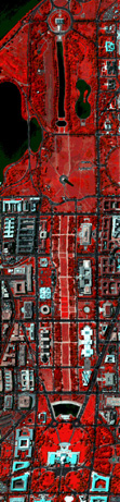
NOTE TO JOURNALISTS: The text of David Landgrebe's keynote lecture at the Fourth International Conference on GeoComputation is available from Emil Venere at Purdue News Service, (765) 494-4709, emil_venere@purdue.edu. An image of the National Mall in Washington D.C., that was taken with this technology also is available. It is called Landgrebe.spy.
PHOTO CAPTION: This color infrared photograph of the National Mall in Washington, D.C., can be manipulated by a computer program to make a detailed image that distinguishes between rooftops, roads, vegetation and other surface materials. Color photo, electronic transmission, and Web and ftp download available. Photo ID: Landgrebe.spy ABSTRACT
On Information Extraction Principles for Hyperspectral Data Means for optimally analyzing hyperspectral data has been a topic of study for some years. Our work has specifically focused on this topic since 1986. The point of departure for our study has been that of signal theory and the signal processing principles that have grown primarily from the communication sciences area over the last half century. The basic approach has been to seek a more fundamental understanding of high dimensional signal spaces in the context of multispectral remote sensing, and then to use this knowledge to extend the methods of conventional multispectral analysis to the hyperspectral domain in an optimal or near optimal fashion. The purpose of this paper is to outline what has been learned so far in this effort. The introduction of hyperspectral sensors that produce much more detailed spectral data than those previously, provide much-enhanced abilities to extract useful information from the data stream that they produce. In theory, it is possible to discriminate successfully between any specified set of classes of data by increasing the dimensionality of the data far enough. In fact, current hyperspectral data, which may have from a few 10's to several hundred bands, essentially make this possible. However, it is also the case that these more detailed data require more sophisticated data analysis procedures if their full potential is to be achieved. Much of what has been learned about the necessary procedures is not particularly intuitive, and indeed, in many cases is counter-intuitive. In this paper, we shall attempt not only to illuminate some of these counter-intuitive aspects, but to point the direction for practical methods to make optimal analysis procedures possible.
|
